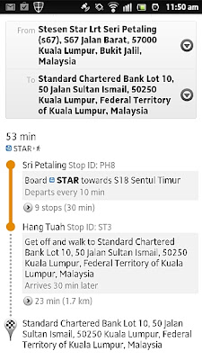
Google Malaysia today announced that it has added Bahasa Malaysia, Traffic and Transit support for Google Maps users in Malaysia on both the desktop and mobile versions of the application.
With the Traffic feature, you can now track traffic conditions in real-time right in Google Maps with colour-coded indicators showing whether a stretch of road is congested or free-flowing. However at launch, the service is available for roads in Klang Valley only.
The Transit feature on Google Maps provides step-by-step travel directions to travel using the public transportation system in Malaysia including bus, LRT, monorail and Komuter. Transit also gives users information on where bus stops and train stations are located.
Google says that the data used for the Traffic and Transit features is gathered from a variety of sources including the Department of Transportation, private data providers, and users of Google Maps for mobile who contribute anonymous speed information through Google’s traffic crowdsourcing feature.
We’ve tested the feature briefly and while Transit is not perfect, it does provide a good general guidance if you have no clue as to which bus or train to catch to head to a particular destination. Traffic on the other hand is spot-on, the real-time traffic update is immensely useful as a traffic monitoring tool giving you accurate information on traffic conditions allow you to plan your travel in advance.
Traffic, Transit and BM language support are much welcomed but we’re kind of disappointed there’s still no support for Google Navigation here in Malaysia. In any case, the three new enhancements is a good start. Here’s hoping that other cool and useful Google Maps features will make it to Malaysia very soon.
In the meantime, you can check out Traffic Transit and BM language support on maps.google.com.my

Blog Topics
- health (1)
- Internship Report (30)
- Kapersky keys (1)
- On the spot movie (25)
- Premium Account (1)
- Tech (42)
- Tv-Shows (6)
Blog Archive
-
►
2013
(5)
- February 2013 (5)
-
▼
2012
(1047)
- December 2012 (24)
- November 2012 (29)
- October 2012 (26)
- September 2012 (10)
- August 2012 (23)
- July 2012 (40)
- June 2012 (69)
- May 2012 (169)
- April 2012 (64)
- March 2012 (165)
- February 2012 (213)
- January 2012 (215)
-
►
2011
(366)
- December 2011 (109)
- November 2011 (98)
- October 2011 (66)
- September 2011 (59)
- August 2011 (11)
- July 2011 (8)
- June 2011 (2)
- May 2011 (1)
- March 2011 (12)
-
►
2010
(23)
- June 2010 (9)
- April 2010 (5)
- March 2010 (1)
- January 2010 (8)
-
►
2009
(103)
- December 2009 (15)
- November 2009 (6)
- October 2009 (17)
- September 2009 (4)
- August 2009 (23)
- July 2009 (18)
- June 2009 (8)
- May 2009 (12)


